Kategorie:Karte
Aus Liebliches-Feld.net
Alle Karten.
Unterkategorien
Diese Kategorie enthält die folgenden 8 Unterkategorien (8 insgesamt):
G
- Gewässerkarte (39 D)
- Grundriss (39 D)
K
- Kartenmarkierung (27 D)
L
- Lehenskarte (110 D)
P
- Positionskarte (20 D)
S
- Stadtplan (106 D)
- Stadtplanausschnitt (225 D)
- Straßenkarte (36 D)
Medien in der Kategorie „Karte“
Folgende 101 Dateien sind in dieser Kategorie, von 101 insgesamt.
-
 1000 Meilen.jpg 800 × 1.196; 150 KB
-
 Ausschnitt Fostanova.jpg 359 × 313; 57 KB
-
 Baronie sewamund.jpg 550 × 700; 69 KB
-
 Battalia-sewamund.jpg 984 × 906; 86 KB
-
 Arinken Ausschnittdetailliert.jpg 438 × 336; 83 KB
-
 Baronie ruthor.gif 170 × 94; 6 KB
-
 Droler Mark.jpg 1.000 × 700; 141 KB
-
 Dörfer Coverna.jpg 850 × 617; 98 KB
-
 Efferdas-1027BF.PNG 849 × 711; 43 KB
-
 Karte drol.jpg 600 × 302; 29 KB
-
 KH-1032.PNG 849 × 711; 42 KB
-
 KV-1032.PNG 849 × 711; 43 KB
-
 Lehen744.jpg 1.000 × 1.135; 78 KB
-
 Lehen752.jpg 1.000 × 1.134; 85 KB
-
 Lehen777.jpg 1.000 × 1.134; 85 KB
-
 Lehen823.jpg 1.000 × 1.134; 85 KB
-
 Lf bergbau.png 612 × 915; 96 KB
-
 Lf klimatisch.png 612 × 915; 103 KB
-
 Lf landschaftlich.png 612 × 915; 80 KB
-
 Lf Shinxir.png 612 × 915; 83 KB
-
 Novadisturm 1026.jpg 599 × 461; 85 KB
-
 ResidenzenCalven.jpg 800 × 1.196; 146 KB
-
 Signorietribec.jpg 723 × 464; 73 KB
-
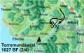
 TMZ 1027 1.jpg 593 × 376; 59 KB
-
 TMZ 1027 2.jpg 593 × 376; 64 KB
-
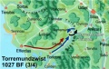 TMZ 1027 3.jpg 593 × 376; 62 KB
-
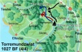 TMZ 1027 4.jpg 593 × 376; 64 KB
-
 Torrem Coverna.jpg 570 × 596; 37 KB
-
 Umland Shenilos.jpg 708 × 456; 120 KB
-
 Urbasiglia grob.jpg 593 × 573; 122 KB
-
 Werften.jpg 1.000 × 1.135; 146 KB
-
 Wirtschaft der baronie sewamund.gif 236 × 254; 21 KB
-
 Calvenslehen.png 612 × 915; 169 KB
-
 Das-Horasreich-Die-Barone.jpg 1.000 × 976; 318 KB
-
 Das-Horasreich-Die-Fürsten.jpg 1.000 × 976; 248 KB
-
 Despotat Ponterra.jpg 804 × 768; 144 KB
-
 Despotat PonterramitHausgut.jpg 732 × 695; 144 KB
-
 Dialekte Calven-Entwurf.jpg 431 × 644; 144 KB
-
 Dialekte-torrem-entwurf.jpg 612 × 915; 88 KB
-
 Domänen 1045.png 2.550 × 3.507; 14,93 MB
-
 Eicheninsel, Baustelle der Spundwand.png 359 × 359; 7 KB
-
 Eicheninsel, Landestelle.png 718 × 1.098; 42 KB
-
 Eicheninsel.jpeg 500 × 500; 22 KB
-
 Gerondrata detailliert.jpg 725 × 691; 181 KB
-
 Gugellabrueck.png 1.658 × 1.386; 76 KB
-
 Herrschaft Gugellaquell.jpg 1.120 × 955; 306 KB
-
 Horasreich Herrschaften Hzm-Kuslik.jpg 1.315 × 1.303; 231 KB
-
 Horasreich.png 1.000 × 1.135; 454 KB
-
 HorasreichAurelat.png 676 × 767; 436 KB
-
 HorasreichChababien.png 676 × 767; 386 KB
-
 HorasreichCoverna.png 676 × 767; 373 KB
-
 HorasreichGerondrata.png 676 × 767; 420 KB
-
 HorasreichHarodien.png 676 × 767; 357 KB
-
 HorasreichKernlande.png 676 × 767; 422 KB
-
 HorasreichMitte.png 676 × 767; 506 KB
-
 HorasreichNord.png 676 × 767; 552 KB
-
 HorasreichOstzyklopen.png 676 × 767; 307 KB
-
 HorasreichSeptimana.png 676 × 767; 346 KB
-
 HorasreichSued.png 676 × 767; 440 KB
-
 HorasreichWestzyklopen.png 676 × 767; 104 KB
-
 HorasreichYaquirbruch.png 676 × 767; 408 KB
-
 K Zyklopeninseln.png 800 × 491; 249 KB
-
 Kaiserjagd1.jpg 676 × 767; 120 KB
-
 Kaiserjagd2.jpg 676 × 767; 96 KB
-
 Kaiserjagd3.jpg 676 × 767; 87 KB
-
 Kaiserjagd4.jpg 676 × 767; 81 KB
-
 Kaiserjagd5.jpg 676 × 767; 78 KB
-
 Karte Altanquirtal.jpg 1.200 × 1.692; 463 KB
-
 Karte der alten Sewaklande.jpg 378 × 288; 37 KB
-
 Karte Landherrenhändel.jpg 640 × 426; 105 KB
-
 Karte Marudreter Fehde klein.jpg 675 × 458; 143 KB
-
 Karte suedmeer.gif 575 × 207; 24 KB
-
 Katzenkrallenszenario Karte.jpg 378 × 505; 82 KB
-
 KraftlinienLF.jpg 1.275 × 1.754; 765 KB
-
 Krieg in der Urbasiglia.jpg 733 × 539; 96 KB
-
 Landhaus A'Temelon.png 640 × 800; 123 KB
-
 Lf bodennutzung.png 612 × 915; 81 KB
-
 Lf bunt g.PNG 612 × 915; 109 KB
-
 LF gruen.png 600 × 710; 72 KB
-
 LF grün links.png 425 × 580; 7 KB
-
 LF grün rechts.png 425 × 580; 8 KB
-
 Liebliches-Feld-Signorien.png 363 × 544; 53 KB
-
 Magna Thalassea Handel.png 850 × 1.198; 116 KB
-
 Olbris1.png 1.755 × 2.580; 177 KB
-
 Olbris2.png 1.854 × 2.671; 164 KB
-
 Olbris3.png 1.829 × 1.282; 88 KB
-
 Perlhaven Landschaft.png 1.616 × 2.291; 569 KB
-
 Ponterrapol.jpg 1.396 × 1.291; 152 KB
-
 Ramaúd Kupferküste.png 450 × 386; 285 KB
-
 Schlacht um Urbet1.jpg 1.500 × 1.211; 216 KB
-
 Seestaedte.png 911 × 1.078; 37 KB
-
 Sewaanimation.gif 450 × 450; 161 KB
-
 Sewamund Umgebung.png 1.230 × 1.658; 1,3 MB
-
 Sheniloer Bund.jpg 691 × 730; 125 KB
-
 SheniloUmland.jpg 1.396 × 1.291; 144 KB
-
 Speculum Aves.jpg 150 × 157; 17 KB
-
 TriarchonDeckplan.png 250 × 362; 6 KB
-
 Urbasi Politische Grenzen 1046.jpg 800 × 541; 156 KB
-
 Wellenfels.jpg 809 × 188; 36 KB
-
 Westalmada.png 676 × 767; 1,13 MB
-
 Windhag.png 676 × 767; 948 KB


